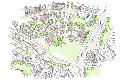

Snowhill is a large 120 acre site located to the North of Wakefield's City Centre and owned by Yorkcourt Properties Ltd. The site has excellent links to the local and national road networks and is within walking distance of the City Centre and its national public transport links.
Paragon Business Park is located in the North East segment of the site with direct access off the A650, which forms the Eastern boundary of the site. To the West the site is bounded by a mix of residential properties.
The brief was given to Simon whilst at careyjones architects to develop a masterplan for outline planning submission to include future phases of commercial use adjacent the successful Paragon Business Park, together with a large scale family housing development. The potential for community uses including a new primary school was also to be developed as part of the final plan.
Key to resolving the final scheme was the desire to create a new neighbourhood that had a sense of place, whilst being connected to the surrounding areas and City Centre. A strategy was developed for both primary and secondary vehicular and pedestrian routes with as many linkages into the existing infrastructure as possible to both facilitate linkages to the existing neighbourhoods whilst spreading any traffic load across the network. Of key importance was the unlocking of the existing highways 'knot' to the Southern end of the site which precluded good pedestrian connectivity to the City Centre. The solution developed enables pedestrians to freely move on and off the site with a simple at-grade crossing, avoiding multiple crossings or bridge links were deemed unacceptable.
The proposed residential units are arranged as a series of connecting urban blocks, interspersed with a series of green squares and avenues providing a 'green amenity infrastructure' to the overall site. The existing central East/West sloping green wedge is retained and improved as part of this green infrastructure creating North and South neighbourhoods helping reduce the scale of the whole.
The proposed primary school is located around the centrally located listed farm building and takes advantage of available open space, woodland and the existing East/West pedestrian connection which cuts through the site.
The majority of the proposed new commercial space is arranged down the Eastern portion of the site, forming a physical break between the proposed residential neighbourhoods and the dual-carriageway of the A650. This general rule is deliberately broken at one point with a spur of residential pushing out to the East. This was developed to encourage pedestrian movement to the existing amenities and neighbourhoods without the need to traverse commercially occupied land.
In total the masterplan provided for approximately 1100 new homes and 575,000 sq ft of commercial space together with community and ancillary uses